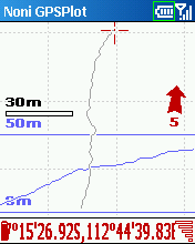
Description:
This tool allows you to locate your position in relation with other GPS points, to see the journey you have traveled.
You can find back your place at harbour after a trip on boat, the starting point of an excursion or locate your car in a huge car park,
A place of which you know the location,
To see the excursion you made,
Speed trap alert or lots of other things...
Tracks and saved points can be exported to GoogleEarth and to GPX standard.
Put your old tracks in the background with a system of tracing,
Put maps in the background (moving map),
Display a graph of altitude, speed or signal level.
New Features:
# New navigation menus
# New system of calculating the approach speed to a point
# Dashboard specific to navigation
# Possibility to choose the thickness of the trace
# 2nd dashboard
# New statistics
# Possibilities to darken or reverse cards in night mode
# Choice auto zoom limit level
# Export in CSV
# New keys
# Export of the party selected of the track
# Trace of altitude more visible
# Some other things...
Requirements:
* Smartphone Windows Mobile 2003
* Smartphone Windows Mobile 5.0
* Smartphone Windows Mobile 6.0
More information:
http://aeguerre.free.fr/Public/PocketPC/NoniGPSPlot/EN/index.php
Download
Download .EXE
Download .CAB
.
.
.

Custom Search
Tuesday, July 15, 2008
NoniGPSPlot v2.73d for Smartphone
Posted by
deBLor
at
10:19
![]()
Labels: GPS / Compass
Subscribe to:
Post Comments (Atom)
No comments:
Post a Comment