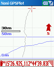
Description:
This tool allows you to locate your position in relation with other GPS points, to see the journey you have traveled.
You can find back your place at harbour after a trip on boat, the starting point of an excursion or locate your car in a huge car park,
A place of which you know the location,
To see the excursion you made,
Speed trap alert or lots of other things...
Tracks and saved points can be exported to GoogleEarth and to GPX standard.
Put your old tracks in the background with a system of tracing,
Put maps in the background (moving map),
Display a graph of altitude, speed or signal level.
New Features:
- Download maps from Internet.
- Address search from Internet.
- Saving type 'history' of the track.
- New type of points (Secondary).
- Internal optimizations for maps rendering.
- Lot of bugs and less.
- Other small things.
- Some other things...
History:
v3.0.1
- Sharing position system
- Dashboard for timing
- New buttons for zooming
- New virtual buttons
- New actions
- Automatic switch to manual zoom and new management of zoom
- Function 'Man Overboard' for naviguation
v2.80:
- Download maps from Internet.
- Address search from Internet.
- Saving type 'history' of the track.
- New type of points (Secondary).
- Internal optimizations for maps rendering.
- Lot of bugs and less.
- Other small things.
v2.74:
- New system of import and export.
- New management of GPS.
- Speed climb.
- New Alerts.
- New keys.
- New statistics.
- Customizable Alerts at point level.
- An alternative keyboard.
- An homemade window for file saving selection.
- Internal Optimizations (case of a large number of points or maps).
- Improved VGA compatibility (?).
- Other small things.
v2.73:
- New navigation menus.
- New system of calculating the approach speed to a point.
- Dashboard specific to navigation.
- Possibility to choose the thickness of the trace.
- 2nd dashboard.
- New statistics.
- Possibilities to darken or reverse cards in night mode.
- Choice auto zoom limit level.
- Export in CSV.
- New keys.
- Export of the party selected of the track.
- Trace of altitude more visible.
- Some other things...
v2.72d:
- New saving format for the track and the points (faster). Warning: If you want to go back to the previous version: Before installing the old version, you have to check 'Old saving format' in the general configuration window to no loose all your points!
- New statellite window.
- Automatic back up of the configuration.
- A system of track recovery in case of reset.
- Some bugs less.
- Some other things...
v2.71b:
- Possibility to import itineraries.
- Improvement of compatibility with the resolutions other than the 320x240.
- Compatible Smartphone.
- Some bugs less.
- Some other things...
v2.71:
- Possibility to import itineraries.
- Improvement of compatibility with the resolutions other than the 320x240.
- Compatible Smartphone with touch screen.
- Some bugs less.
- Some other things...
v2.70c:
- Possibility to update map or group of map calibration.
- UTM format.
- New GPS manager.
- Windows displayed in Anglo-Saxon units.
- Some bugs less.
- Some other things...
v2.69:
- Possibility to click on a point to display his group, name, the cape and outdistance (from current position).
- Possibility to edit a point from a double click.
- Possibility to add a comment to points.
- Possibility to record voice memo to points and use it as alert.
- Possibility to export points from group.
- Possibility to export in NMEA format compatible with Locr.
- Some other things...
v2.6.8d:
- Add battery level.
- Add sound to warn lost of signal.
- New statitic.
- Drift alarm.
- Possibility to activate/deactivate StaticNav (only for some kind of GPS).
- Altitude alert.
- Uneven alert.
- Redisign of map projection.
- Possibility to set memory size for maps.
- Possibility to set alert for signal lost.
- Better compatibility with 240*240.
- Add altitude in KML exports.
- Some other things.
Requirements:
* Smartphone Windows Mobile 2003
* Smartphone Windows Mobile 5.0
* Smartphone Windows Mobile 6.0
More information:
NoniGPSPlot
Download
Download .EXE
Download .CAB
.
.
.

Custom Search
Thursday, August 12, 2010
NoniGPSPlot v3.0.1 for Smartphone
Posted by
deBLor
at
16:07
![]()
Labels: GPS / Compass
Subscribe to:
Post Comments (Atom)


No comments:
Post a Comment