Description:
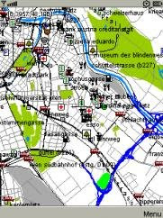
Mario Advisor is a free java utility to display Garmin IMG maps in your mobile.
Free garmin maps can be downloaded from many sources around the web (see this and this search engines), or translated from Open Street Map data (see conversion details and resources ). You can even create your own maps with the aid of GPSMapEdit and cGPSmapper.
External Maps installation:
Create a maps folder in your mobile's root filesystem (JSR75 needed) and copy Garmin IMG files. No previous conversion is needed. Mario Advisor will display map data and labels for roads, Points Of Interest and cities. Search capabilities are under development.
Internal Maps installation:
Maps can also be stored inside the Jar file, to avoid the confirmation request every time a file is accessed. To do so, copy maps in the "maps" folder inside the Jar, and update the file "map_list.txt" with the names of the files included. Check your mobile can intall the new Jar, since midlet size will be bigger.
GPS Support:
Internal JSR179 and Bluetooth external GPS with NMEA sentencies are supported. When GPS connection is ON, view is centered in current location.
Keys:
Up,down,left,right: pan
Fire,0: zoom in/out
*: center view in GPS coordenates
#: road names on/off
History:
Changes in 0.61:
*Added cache to labels in NET subfile
Bugs:
*Fixed crash when unknown point type was found
*Fixed general map view for metroguide north america
*Fixed big bug in label processing with many POI's
*Fixed bug in highway names
*Fixed stop loading with non valid file
Changes in v0.6:
*Locked maps (non NT) supported
*Speed & course displayed when GPS is ON
*Added "Find Nearest" button to search form. Distances are now showed
*Elevation data in meters
*Zoom + & zoom - both in FIRE key. Short press=zoom+, long press=zoom-
*Basic Tracklog. Tracklog file is saved in Ozi Explorer .PLT format
*Backlight control. Tested on Sony Ericsson & Nokia mobiles
*Map selection form, to find out if a IMG file is loaded and to jump between maps
Changes in 0.5:
*Better memory management. Memory requirements relaxed
*Better Out-of-Memory Error Handling
*Performance slightly improved
*Internal GPS (JSR179) support
*Configuration moved to RMS
*Data folder added to options
*Basic Point Search capabilities
Changes in 0.4:
*Purged "extra" Large Cities
*Added internal maps support
*Added bluetooth gps selection form
*POI's labels showed
*Created a cache to store labels
*Improved street labels adjustment
Bugs:
*Fixed clipping function to verify last+first index
*Fixed crash with wrong files
Changes in 0.3:
*Full road/street names support
*Arranged points drawing order. First, indexed points
*Improved clipping algorithm
*Added cache size to config
*Maps with gaps in zoom levels supported
Bugs:
*Fixed labels with [0x1f] code
*Fixed 8-bit road labels with [0x2f] code
*Fixed label process for points out of visible area
*Fixed init with no maps nor initial coordinates
*Fixed Maps continuously regenerating in GPS mode
Requirements:
* Phone with Java
* Free RAM: >1Mb
* Midlet size >200 kb
* GPS
More information:
Mario Advisor
Download
.
.
.

Custom Search
Thursday, February 5, 2009
Mario Advisor v0.61 (Java)
Posted by
deBLor
at
22:48
![]()
Labels: GPS / Compass, Maps
Subscribe to:
Post Comments (Atom)


No comments:
Post a Comment